Mississippi Topo Map
Created By: -Oz-
Last Updated: July 23rd, 2008 11:07am
Map Coverage:
North: 35°
West: -92°
East: -88°
South: 30°
Country: United States
State: Mississippi
Price: Free!
![]()
![]()
![]()
![]()
![]()
![]()
![]()
![]()
Most Popular Maps
- My Trails-High Quality Trail and POI Maps
- Arizona Topo
- World Topo - Eastern
- WV-VA-KY Dec-29 2025 Public Map
- Florida Topo
Other Maps By -Oz- (See All)
Introduction
The purpose of this venture is to create a detailed topographic map of the entire state of Mississippi at 24k detail. This map is created for Garmin GPS receivers and Mapsource.
Features
- Roads - Interstates, highways, roads, limited unpaved roads
- Railroads
- High resolution water data - lakes, rivers, streams, marshes, and washes
- Federal Land Usage - Wilderness area, national parks, and military bases/ranges, native american reservations, some state parks
- Borders - County and state boundary lines
- Elevation contours - 10ft intervals (equivalent to 24k)
- GNIS Points of Interest - summits, mines, falls, dams, cemeteries, towers, populated places, etc.
- Trails - trail coverage inside of the national parks/forests
- Parks POI - trailheads, camping sites, forest service huts within the national parks/forests
- ~100k Grid Segments - no segment larger than 7mb means most older GPSr's can use this mapset
Coverage
This map covers the entire state of Mississippi. Contour and water data exists slightly outside of the state boundaries.
Screenshots
These two screenshots show the Mississippi Topo on a Garmin 60csx:
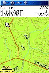

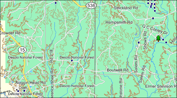
This screenshot demonstrates how this topo looks in the new version of Garmin MapSource:
This final screenshot compares the Mississippi Topo to Garmin's US Topo East and Garmin's Topo 2008:

Installation
Two options exist; for windows download and run setup. The map will then appear in Garmin MapSource and can be added to your GPS by selecting it in MapSource and sending it to the GPSr. For Mac download the mac version, extract it and double click the .gmapi file. Map Manager will then install the map for you.
Version 1.0 Released 23 Jul 08
Download Windows Version [142MB] (13063 Downloads)
Download Mac Version [142MB] (3436 Downloads)
GPS Usage
This map can be installed with any other Garmin Maps (How-To Tutorial). Then you simply hide and show other maps until you see the Mississippi Topo. For more detailed instructions check out this tutorial.
Support The Effort
Although this map is free, and always will be if you find the map useful please consider making a donation to offset software, hardware, and hosting costs.
* You don't need paypal to donate but that is who will process the donation.
If you can't donate (or even if you can) another great way to help is by providing data for this map or other maps. If you have data please contact me.
References
Many resources were used to create this map, the main ones are listed here:
- USGS National Elevation Data (NED)
http://ned.usgs.gov/
The NED is elevation data provided in raster form by the USGS. - USGS National Hydrography Dataset
http://nhd.usgs.gov
The USGS provides hydrographic data in high resolution. - USGS National Geographic Names Information System (GNIS)
http://geonames.usgs.gov/pls/gnispublic
The USGS provides locations and names for many features throughout the United States. - FSGeodata Clearinghouse
http://svinetfc4.fs.fed.us/clearinghouse/index.html
The Forest Service provided trail and POI data for all national forests and parks in Mississippi.
Changelog
Version 1.00 (23 Jul 08)
- Initial release