Nevada Topo Map
Created By: -Oz-
Last Updated: April 30th, 2016 12:04pm
Map Coverage:
North: 42.0062°
West: -120.031°
East: -114°
South: 35.0024°
Country: United States
State: Nevada
Price: Free
![]()
![]()
![]()
![]()
![]()
![]()
![]()
![]()
Most Popular Maps
- My Trails-High Quality Trail and POI Maps
- Arizona Topo
- World Topo - Eastern
- WV-VA-KY Dec-29 2025 Public Map
- Florida Topo
Other Maps By -Oz- (See All)
Introduction
The purpose of this venture is to create a detailed topographic map of the entire state of Nevada at 24k detail. This map is created for Garmin GPS receivers and Mapsource/BaseCamp.
Features
- Roads - Interstates, highways, arterial roads, residential roads, limited unpaved roads (2015 Tiger Data)
- Railroads
- High resolution water data - lakes, rivers, streams, and washes
- Federal Land Usage - Wilderness area, national parks, and military bases/ranges, native american reservations
- Borders - County and state boundary lines
- Elevation contours - 1:24k contour intervals (10ft to 40ft depending on the area)
- Points of Interest - summits, mines, falls, dams, cemeteries, towers, populated places, etc. plus National Forest points.
- Trails - trail coverage including all National Forests
Coverage
This map covers the entire state of Nevada.
Screenshots
Below is a picture of the map inside of Garmin BaseCamp:
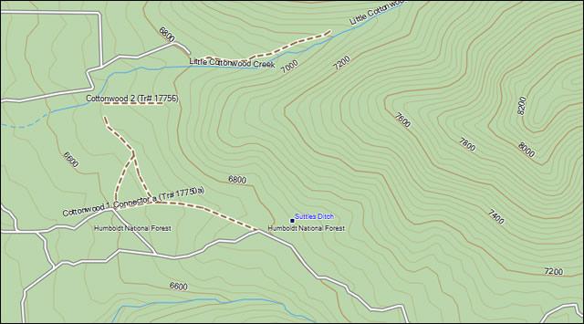
This screenshot compares the Nevada Topo (left) to Garmin US Topo (middle) to Garmin Topo 2008 (right). With the exception of the DEM shading you can see that the Nevada Topo is significantly more detailed.

Installation
Two options exist; for windows download and run setup. The map will then appear in Garmin MapSource or Garmin BaseCamp and can be added to your GPS by selecting it in MapSource or BaseCamp and sending it to the GPSr. For Mac download the mac version, extract it and double click the .gmapi file. Map Manager will then install the map for you.
Version 2.0 Released 30 Apr 16
Download Windows Version [166MB] (34583 Downloads)
Download Mac Version [165MB] (10598 Downloads)
GPS Usage
This map can be installed with any other Garmin Maps (How-To Tutorial). Then you simply hide and show other maps until you see the Nevada Topo. For more detailed instructions check out this tutorial.
Support The Effort
Although this map is free, and always will be if you find the map useful please consider making a donation to offset software, hardware, and hosting costs. There is a donate button at the bottom of this page or on the download page.
If you can't donate (or even if you can) another great way to help is by providing data for this map or other maps. If you have data please contact me.
Changelog
Version 2.00 (30 Apr 16)
- Upgraded the Windows installer to work with Windows 10 64-bit and BaseCamp
- All updated data.
- Change contour intervals to true 1:24K data (except in one section of the state where the data was missing, that section has 20ft interval data
- Updated roads
- Updated water data
- Updated federal lands data (added fish & wildlife refuges)
- Updated GNIS points
- Compiled with a different program
- Reduced the number of map segments to 33
- Searchable Points of Interest
Version 1.00 (10 Jan 09)
- Initial release