Arizona Topo Map
Created By: -Oz-
Last Updated: August 17th, 2016 7:08pm
Map Coverage:
North: 37°
West: -115°
East: -109°
South: 31°
Country: United States
State: Arizona
Price: Free
![]()
![]()
![]()
![]()
![]()
![]()
![]()
![]()
Most Popular Maps
- My Trails-High Quality Trail and POI Maps
- Arizona Topo
- World Topo - Eastern
- WV-VA-KY Dec-29 2025 Public Map
- Florida Topo
Other Maps By -Oz- (See All)
Introduction
The purpose of this venture is to create a detailed topographic map of the entire state of Arizona at 24k detail. This map is created for Garmin GPS receivers, Mapsource, RoadTrip, and BaseCamp. The most recent version was released on the 15th of March 2016 and includes major improvements over previous versions.
Features
- Roads - Interstates, highways, arterial roads, residential roads, limited unpaved roads (2015 Census Tiger Data)
- Railroads
- High resolution water data - lakes, rivers, streams, and washes
- Federal Land Usage - Wilderness area, national parks, BLM land, military bases/ranges, and native american reservations
- Borders - County and state boundary lines
- Elevation contours - 24K:1 interval (standard USGS topos) with intervals varying between 10ft and 40ft depending on the terrain
- Points of Interest (over 37,000) - search for summits, mines, falls, dams, cemeteries, towers, populated places, U.S. Forest Service recreation sites, etc.
- Trails - trail coverage including: Grand Canyon, Sunrise Ski Park, Granite Mountain Recreation Area trails, Sedona, National Forests, National Parks, and a many others throughout the state
- Apache-Sitgreaves National Forest snowmobile trails
Coverage
This map covers the entire state of Arizona.
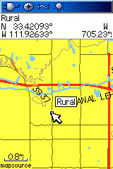
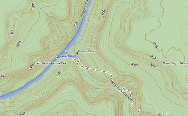
Screenshots
Below are a couple examples of this map on a Garmin 60csx:

Below is a picture of the map inside of Garmin BaseCamp:
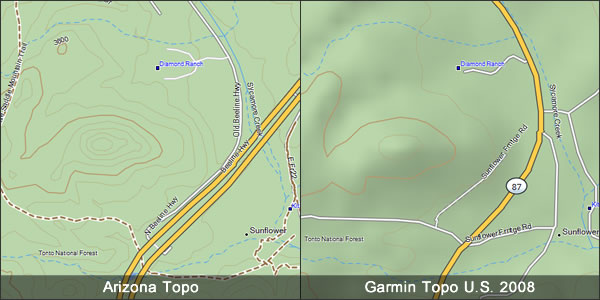
This screenshot compares the Arizona Topo (v3.0) (left) to Garmin Topo U.S. 2008 (right). With the exception of the DEM shading you can see that the Arizona Topo is significantly more detailed and in this case has more current roads and better trail data.
Installation
Two options exist; for windows download and run setup. The map will then appear in and BaseCamp and can be added to your GPS by using BaseCamp's mapinstall and sending it to the GPSr. For Mac download the mac version, extract it and double click the .gmapi file. Map Manager will then install the map for you.
Version 3.01 Released 15 Mar 2016
Download Windows Version [185MB] (110798 Downloads)
Download Mac Version [185MB] (25765 Downloads)
Like Arizona? Download its neighbor - New Mexico
GPS Usage
This map can be installed with any other Garmin Maps (How-To Tutorial). Then you simply hide and show other maps until you see the Arizona Topo - check out this tutorial.
Support The Effort
Although this map is free, and always will be if you find the map useful please consider making a donation to offset software, hardware, and hosting costs. Please click the link at the bottom of the page.
If you can't donate (or even if you can) another great way to help is by providing data for this map or other maps. If you have data please contact me.
Changelog
Version 3.01 (15 Mar 16)
- Fixed a Windows installer issue to work better with BaseCamp and Windows 10 64-bit
Version 3.0 (19 Jan 16)
- All updated data.
- Change contour intervals to true 1:24K data
- Updated roads
- Updated water data
- Updated federal lands data (added fish & wildlife refuges)
- Updated GNIS points
- Compiled with a different program
- Reduced the number of map segments from 46 to 36
- Increased segment size from 1 degree x 3/4 degree to 1 degree x 1 degree
Version 2.11 (23 Oct 11)
- Updated the Windows installer to fix an issue with Garmin Basecamp on Windows 7 64-bit
Version 2.11 (24 Jul 11)
- Added additional trails
Version 2.10 (22 Aug 10)
- Fixed error on older units where names would be displayed as "N...... V......"
- All points of interest are now searchable
- Improved installer/uninstaller information
Version 2.00 (10 Mar 10)
- Reduced the number of map segments from 68 to 46
- Increased segment size from 1 degree x 1/2 degree to 1 degree x 3/4 degree (minimum)
- Fixed duplicate/double trails throughout the state; especially in the Grand Canyon area
- Updated the road data to the 2009 Census data
- Included USFS recreation points
- Updated the GNIS POIs
- Decreased the contour interval from 40ft to 30ft
- Used new DEM data providing improved accuracy in certain areas
- Added many additional trails
- Added Apache-Sitgreaves snowmobile trails
Version 1.25 (2 Jan 09)
- Fixed elevation errors that occurred throughout entire state.
Version 1.2 (30 Dec 08)
- Updated to 2008 National Tiger Road Data
- Fixed issues with roads in Pima County
- Updated to 2008 National Tiger Rail Data
- Updated major power lines (2008 Tiger)
- Updated airport runways (2008 Tiger)
- Updated many trails including adding National Forest Service Trails (increased from <50 to >400)
- Removed duplicate trails
- Made map end at the state border (easier to not have issues with neighboring maps)
- Updated GNIS (points of interest) points
Version 1.1 (16 Jun 08)
- Updated to 2007 National Tiger Road Data
- Updated to 2007 National Tiger Railroad Data
- Added major powerlines
- Included airport runways (2007 Tiger Data)
- Included Native American Reservations
- Updated Grand Canyon Trails (removed duplicates)
- Fixed trails marked as roads
- Fixed road locations in Pima County
Version 1.02 (12 Apr 08)
- Fixed error with 18 quads still having the contour bug; learned how to prevent it in the future.
- Created and released Mac version
Version 1.01 (11 Apr 08)
- Fixed large error with contours having the wrong elevations
Version 1.00 (6 Apr 08)
- Initial release