MT Deer-Elk-Lion Hunting Districts 2023 Map
Created By: yogazoo
Last Updated: June 17th, 2023 12:06am
Map Coverage:
North: 49.0004°
West: -116.051°
East: -104.039°
South: 44.3573°
Country: United States
State: Montana
Price: FREE
![]()
![]()
![]()
![]()
![]()
Most Popular Maps
- My Trails-High Quality Trail and POI Maps
- Arizona Topo
- World Topo - Eastern
- Florida Topo
- World shaded relief kmz
Other Maps By yogazoo (See All)
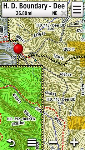
This map is a transparent overlay that shows the statewide hunting district boundaries of Montana's Deer-Elk-Lion hunting season 2023. This map will show hunting district boundaries, district portion boundaries, and will show the H.D. number when you pan your GPS pointer over any desired location. You can enable this map over any topo or street map you have on your GPS!!
If you have any questions please contact me at: [email protected]
For screenshots, detailed description, other species, and to download the installer for PC and MAC please visit our website: http://gpsmapsmontana.com/shop/hunting-districts/
 Download Windows Version [6MB] (4595 Downloads)
Download Mac Version [6MB] (968 Downloads)
This map is a transparent overlay shown below over a topo map.