New Mexico Topo Map
Created By: -Oz-
Last Updated: March 20th, 2016 6:03pm
Map Coverage:
North: 37°
West: -109.026°
East: -103°
South: 31.3125°
Country: United States
State: New Mexico
Price: Free!
![]()
![]()
![]()
![]()
![]()
![]()
![]()
![]()
Most Popular Maps
- My Trails-High Quality Trail and POI Maps
- Arizona Topo
- World Topo - Eastern
- WV-VA-KY Dec-29 2025 Public Map
- Florida Topo
Other Maps By -Oz- (See All)
Introduction
The purpose of this venture is to create a detailed topographic map of the entire state of New Mexico at 24k detail. This map is created for Garmin GPS receivers and BaseCamp. It received a complete overhauld in 2016.
Features
- Roads - Interstates, highways, roads, limited unpaved roads (2015 Census Tiger Data)
- Railroads
- High resolution water data - lakes, rivers, streams, marshes, and washes
- Federal Land Usage - Wilderness area, national parks, and military bases/ranges, native american reservations, some state parks
- Borders - County and state boundary lines
- Elevation contours - 24K:1 interval (standard USGS topos) with intervals varying between 10ft and 40ft
- Points of Interest - search for summits, mines, falls, dams, cemeteries, towers, populated places, U.S. Forest Service recreation sites, etc.
- Trails - trail coverage inside of the national parks/forests as well as state parks
Coverage
This map covers the entire state of New Mexico.
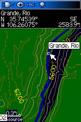
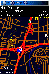
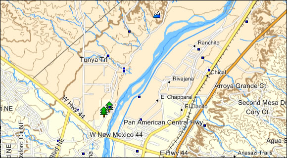
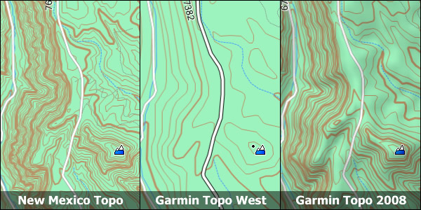
Screenshots
These two screenshots show the New Mexico Topo on a Garmin 60csx (night mode) On the left is the Rio Grande and two trails. On the right is Albuquerque at the I-25 I-40 interchange:
This screenshot demonstrates how this topo looks in the new version (6.14.X+) of Garmin MapSource:
This final screenshot compares the New Mexico Topo to Garmin's US Topo West and Garmin's Topo 2008:
Installation
Two options exist; for windows download and run setup. The map will then appear in Garmin BaseCamp and can be added to your GPS by selecting it in BaseCamp and sending it to the GPSr. For Mac download the mac version, extract it and double click the .gmapi file. Map Manager will then install the map for you.
Version 2.0 Released 20 March 2016
Download Windows Version [161MB] (43019 Downloads)
Download Mac Version [160MB] (9429 Downloads)
Like New Mexico? Check out Arizona
GPS Usage
This map can be installed with any other Garmin Maps (How-To Tutorial). Then you simply hide and show other maps until you see the New Mexico Topo. For more detailed instructions check out this tutorial.
Support The Effort
Although this map is free, and always will be if you find the map useful please consider making a donation to offset software, hardware, and hosting costs. The link to donate is at the bottom of the page.
Changelog
Version 2.00 (20 Mar 16)
- Upgraded the Windows installer to work with Windows 10 64-bit and BaseCamp
- All updated data.
- Change contour intervals to true 1:24K data
- Updated roads
- Updated water data
- Updated federal lands data (added fish & wildlife refuges)
- Updated GNIS points
- Compiled with a different program
- Reduced the number of map segments from 46 to 36
- Increased segment size from 1 degree x 3/4 degree to ~1 degree x ~1 degree
- Searchable Points of Interest
- Symbols for Interstates and US Hwys
Version 1.50 (23 Oct 11)
- Upgraded the Windows installer to correct an issue with Windows 7 64bit Basecamp
Version 1.50 (25 Oct 10)
- Increased the number of trails included in the map
- Fixed a glitch with missing data on the state border
- Decreased contour interval to 30ft
- Added National Park Service campsites and trails
- Includes Albuquerque City Parks and Open Space including trails
- Updated roads data
- Updated water data
- Updated points of interest
- Created searchable points of interest
Version 1.00 (20 Sep 08)
- Initial release
- Note: Hospital POI may have issues; report any errors you find