Massachusetts Topo Map Map
Created By: savage
Last Updated: August 15th, 2008 7:08pm
Map Coverage:
North: 43°
West: 74°
East: 69°
South: 41°
Country: United States
State: Massachusetts
Price: Free
![]()
![]()
![]()
![]()
![]()
![]()
![]()
Most Popular Maps
- My Trails-High Quality Trail and POI Maps
- Arizona Topo
- World Topo - Eastern
- Florida Topo
- World shaded relief kmz
Other Maps By savage (See All)
Introduction
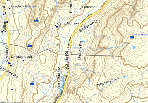
This is a topographic map of the state of Massachusetts. It includes contour lines (50ft), county and state boundaries, roads, water, federal land, and other data.
Screenshot
Installation
Two options exist; for windows download and run setup. The map will then appear in Garmin MapSource and can be added to your GPS by selecting it in MapSource and sending it to the GPSr. For Mac download the mac version, extract it and double click the .gmapi file. Map Manager will then install the map for you.
Version 1.0 Released 12 Aug 08
Download Windows Version [34MB] (9734 Downloads)
Download Mac Version [34MB] (3470 Downloads)
The original download is available at Game and Fish Network - Massachusets Map (PC Only); it may be more recent.
GPS Usage
This map can be installed with any other Garmin Maps (How-To Tutorial). Then you simply hide and show other maps until you see the Massachusetts Topo. For more detailed instructions visit here.
About
This map was created by Savage who runs Game and Fish Network. This work is licensed under a Creative Commons Attribution-Noncommercial-Share Alike 3.0 United States License.