California Topo Map
Created By: -Oz-
Last Updated: August 1st, 2008 7:08am
Map Coverage:
North: 42.0447°
West: -124.505°
East: -114°
South: 32.4976°
Country: United States
State: California
Price: Free
![]()
![]()
![]()
![]()
![]()
![]()
![]()
Most Popular Maps
- My Trails-High Quality Trail and POI Maps
- Arizona Topo
- World Topo - Eastern
- WV-VA-KY Dec-29 2025 Public Map
- Florida Topo
Other Maps By -Oz- (See All)
Introduction
NOTE: A much more accurate and current California Topo is available here. GPSFileDepot recommends the new 2011 California Topo.
This map is a release of the California Topo map by Laura Sanborn. The original download is no longer available. With her help and permission GPSFileDepot was able to compile the map into a version that includes a Mac and Windows installer so that older GPS units can take just the sections they need. It eliminates the need to have a new GPS and a completely blank microSD/SD card.
Features
- Roads - Interstates, highways, roads, limited unpaved roads (not from the most recent Tiger data)
- Railroads
- Water data - lakes, rivers, streams, etc
- Elevation contours - 20ft intervals (very similar to 24k topo)
- Trails - trail coverage from 100k DLG files
- No points of interest or elevation contours for areas below sea level. If you want these use the new California Topo.
Coverage
This map covers the entire state of California.
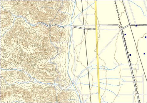
Screenshots
This screenshot shows the California topo in Garmin MapSource:
Installation
Two options exist; for windows download and run setup. The map will then appear in Garmin MapSource and can be added to your GPS by selecting it in MapSource and sending it to the GPSr. For Mac download the mac version, extract it and double click the .gmapi file. Map Manager will then install the map for you.
NOTE: A brand new and much more up to date California Topo is available here. GPSFileDepot recommends the new 2011 California Topo.
Version 1.0 Released 31Jul 08
Download Windows Version [911MB] (45359 Downloads)
Download Mac Version [910MB] (9270 Downloads)
GPS Usage
This map can be installed with any other Garmin Maps (How-To Tutorial). Then you simply hide and show other maps until you see the California Topo. For more detailed instructions check out this tutorial.
References
Many resources were used to create this map, the original map author lists them on her site:
- Laura Sanborn
http://www.vr6.com/gps/map-bg.htm
The sources and more information about the map are listed on the original author's site.
Changelog
Version 1.00 (31Jul 08)
- Initial release