Paiute OHV / ATV Trails v3.1, UT Map
Created By: eaparks
Last Updated: February 28th, 2017 6:02pm
Map Coverage:
North: 39.6144°
West: 112.675°
East: 110.133°
South: 37.2516°
Country: United States
State: Utah
Price: Free
![]()
![]()
![]()
![]()
![]()
![]()
![]()
![]()
Most Popular Maps
- My Trails-High Quality Trail and POI Maps
- Arizona Topo
- World Topo - Eastern
- WV-VA-KY Dec-29 2025 Public Map
- Florida Topo
Other Maps By eaparks (See All)
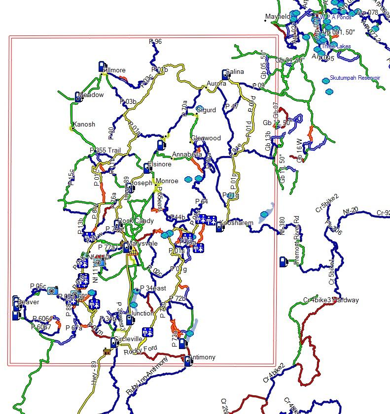
Paiute OHV / ATV GPS map for trails in Utah and surrounding area including trails to/from Paiute to Bryce Canyon, Tropic Reservoir, Gooseberry, Circleville, and Arapeen. More than 2,000 miles of trails.
2-28-17 - version 3.1. Several updates from Aug. 2016 trip. Added several places to eat, more restrooms alongs trails, color coded the 50" restricted trails as to Intermediate or Difficult, added City Streets that are legal for OHVs, added polygons for large lakes/reservoirs, many new POIs added. New map image added. Before installing this new map, "Paiute Trails v3.1", you should uninstall "Paiute Trails v1.1", if you had installed it.
8-21-13 - Added Map image
4-2-12 - version 1.1. Thanks to K. Dastrup for providing trail updates improving the accuracy of trails: P 53b, P 33east1, P 33east2, P 33east3, P 33east4, and P 54. Removed trail P 5997. Before installing this new map, "Paiute Trails v1.1", you should uninstall "Paiute Trails", if you had installed it.
4-4-11 - Thanks to Gary Bushman (atvutah.com) for providing updates. Removed trails "P 77d" and "P 71" due to crossing on to private property. Added a new trail "P 77d Bullion Falls". Added a new POI for "Marysvale Miner Park".
3-31-11 - Added EZ Install for Mapsource, cleaned up tracks/trails, added a few additional POIs, 20 gas station POIs.
9-23-09 - original version
Trails are colored coded by difficulty: (can also be viewed in Readme.txt file)Trail Color Designations are as follows:
- White line with red border = Property Boundaries; ie... Paiute, etc
- Yellow line with thin Green line = City Streets legal for OHVs
- Yellow line = the main Paiute Trail 01 loop
- Green line = Easiest Trails (includes gravel roads)
- Blue line = Intermediate Trails
- Blue line with thin Yellow line = 50" Intermediate Trails
- Red line = Difficult Trails
- Red line with thin Yellow line = 50" Difficult Trails
- Red and Black Dashed line = Extremely Difficult Trails
Please email me with any corrections that need to be made or additional POIs that would be good to add to the map, thank you.
 Download Windows Version [722kB] (9358 Downloads)