Massachusetts: Stow: Gardner Hill Map
Created By: dbperry
Last Updated: January 1st, 2013 12:01pm
Map Coverage:
North: 42.4354°
West: -71.5033°
East: -71.4818°
South: 42.4171°
Country: United States
State: Massachusetts
Price: Free
![]()
![]()
![]()
![]()
![]()
![]()
![]()
Most Popular Maps
- My Trails-High Quality Trail and POI Maps
- Arizona Topo
- World Topo - Eastern
- WV-VA-KY Dec-29 2025 Public Map
- Florida Topo
Other Maps By dbperry (See All)
Gardner Hill / Stow Town Forest, Stow, MA 01775
CLICK HERE to preview the KMZ map in Google Maps
Conservation land owned by the Town of Stow, sometimes referred to as the Stow Town Forest.
More information at:
http://www.stowconservationtrust.org/land.php
and
http://www.stow-ma.gov/pages/stowma_recreation/Walking%20and%20Hiking%20Trails/GardnerHill-TownForest.pdf
A year of pictures of the Town Forest is at:
http://www.stowtownforest.com/
Source Data
My KMZ map is from the Town of Stow Conservation Trust map:
http://www.stowconservationtrust.org/images/maps/GardnerHill.jpg
See below for more information
If you enjoy using this property, consider becoming a member:
http://www.stowconservationtrust.org/donation.php
Screenshots
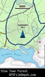
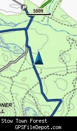
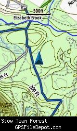
This KMZ map is set to Draw Order 32 so it will show 'beneath' your primary map on your Garmin KMZ-compatible GPS. This KMZ also will appear above my KMZ map of the Assabet River National Wildlife Refuge and under my KMZ map of Red Acre.
The images on the left are from a Garmin GPSMAP 78sc with no other maps displayed. The image on the right is from the same device with the Garmin 24K NE series TOPO maps displayed.
Download
I have posted this KMZ as freeware, so instead of paying me for it, send me a note if you found this file helpful!
[email protected]
 Download Garmin Custom Map [383kB] (1351 Downloads)
Once you have downloaded and unzipped the KMZ file, you can:
1) Display it on your Garmin GPS receiver by placing the file in the \Garmin\CustomMaps folder on your supported Garmin GPS receiver. For a list of supported devices, click here.
2) Display it in Google Earth by opening the file (FILE, OPEN).
Notification of Updates
If you would like to be notified when I update this or any of my KMZ maps, subscribe to my notification e-mail service by sending an e-mail to [email protected] with the subject line "subscribe gps_maps"
This is a notification list only, and the only posts you will receive are when my KMZ maps are updated. Your e-mail address will not be used for any other purpose (or provided to anyone else except me).
Support The Effort
If you find the map and this website useful please consider making a donation to offset hosting costs.
* You don't need paypal to donate but that is who will process the donation.
Version History
Note: This page was updated on 1/1/2013, and the file was re-uploaded, but nothing was changed on the KMZ (only the file name)
Version 1.00 (2012 Apr 19)
Initial release using undated Stow Conservation Trust map (see above)
Map Summary
Site details:
Name: Gardner Hill / Stow Town Forest
Owner / Steward: Stow Conservation Trust
State: Massachusetts
County: Middlesex
Primary city / town: Stow
Primary city / town zip code: 01775
Other cities / towns in map area: <none>
Area of conservation / recreation land: 376 acres or 0.59 square miles
NOTE: This is my calculation of the extents of the area(s) with publicly accessible trails on the KMZ map. This should be the area available for hiking or other recreation, but it will also include any portion of water bodies, marshes, swamps, etc. within the boundaries of the properties on the KMZ. It would also include inaccessible conservation land within the boundaries, such as a buffer zone of "Do not enter" land around a reservoir.
KMZ details:
File name: Gardner_Hill_ver_1.00.kmz
Current version: 1.00
Date published: 4/19/2012
Number of tiles: 1
KMZ file size: 386 KB
Draw order: 32
Does this KMZ overlap with any others? Yes
If so, which ones?
Red Acre
Assabet River National Wildlife Refuge
Coverage of KMZ: 892 acres or 1.39 square miles
NOTE: this area includes the ENTIRE KMZ including white space / margins / legend, etc.
Lat / Long of center of KMZ polygon (not necessarily the center of the map):
N 42° 25.572'
W 71° 29.551'