Yosemite Topo Map
Created By: -Oz-
Last Updated: May 28th, 2008 5:05pm
Map Coverage:
North: 38.5002°
West: -121.002°
East: -118.5°
South: 36.9992°
Country: United States
State: California
Price: Free
![]()
![]()
![]()
![]()
![]()
![]()
![]()
![]()
Most Popular Maps
- My Trails-High Quality Trail and POI Maps
- Arizona Topo
- World Topo - Eastern
- WV-VA-KY Dec-29 2025 Public Map
- Florida Topo
Other Maps By -Oz- (See All)
Introduction
The purpose of this map is to provide detailed topographic coverage of Yosemite National Park and some of its outside areas. This map was created by RoboMatt and was originally distributed via MapCenter; we have recompiled the two maps into one and put it inside an installer and created a mac version.
Features
- Roads
- Trails
- Contours
- Detailed Water Data
- Points of Interest
Coverage & Detail
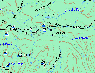
This map covers the entire Yosemite National Park area as well as a few areas outside.
This screenshot illustrates some of the detail:
Installation
Two options exist; for windows download and run setup. The map will then appear in Garmin MapSource and can be added to your GPS by selecting it in MapSource and sending it to the GPSr. For Mac download the mac version, extract it and double click the .gmapi file. Map Manager will then install the map for you.
Version 1.00 Released 28 May 08
Download Windows Version [9MB] (15321 Downloads)
Download Mac Version [9MB] (5421 Downloads)
GPS Usage
This map can be installed with any other Garmin Maps via Garmin MapSource (How-To Tutorial).
References
This map is orginally from another source: