New Jersey Topo Map
Created By: maps4gps
Last Updated: February 28th, 2012 10:02am
Map Coverage:
North: 41.5°
West: -75.75°
East: -73.45°
South: 38.75°
Country: United States
State: New Jersey
Price: free
![]()
![]()
![]()
![]()
![]()
![]()
![]()
Most Popular Maps
- My Trails-High Quality Trail and POI Maps
- Arizona Topo
- World Topo - Eastern
- WV-VA-KY Dec-29 2025 Public Map
- Florida Topo
Other Maps By maps4gps (See All)
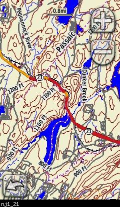
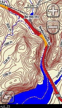
This map covers New Jersey and uses custom type styles developed on an Oregon 300 with shaded relief set to 'do not show'.
Data Sources:
Transportation - Census TIGER (2010 Nov.- 2011 Feb) - enhanced
Hydrology - USGS NHD (2010 Sep)
Contours - 20 ft - created from USGS 1/3 arc sec (about 10m point spacing) NED (2011 Feb).
POI's - USGS GNIS (2011 Feb) - enhanced. NGS benchmarks
Boundaries: State & County from Census TIGER (2011-Feb). BLM surface management data (2011 May).
Screenshots
Below are examples of this map on a Garmin Oregon300:

Installation
Two options exist; for windows download and run setup. The map will then appear in Garmin MapSource and BaseCamp and can be added to your GPS by selecting it in MapSource and sending it to the GPSr. For Mac download the mac version, extract it and double click the .gmapi file. Map Manager will then install the map for you.
Version 2.0 Released June 7, 2011
There is an issue with the 64-bit installer used in the PC version of this mapset. If this is the first mapset you are installing on a Windows 7 64 bit PC, you will need to FIRST install a mapset which used a 32-bit installer, 'My trails ....' http://www.gpsfiledepot.com/maps/view/53 works and is small in size.
Download Windows Version [47MB] (11194 Downloads)
Download Mac Version [47MB] (3331 Downloads)
]
GPS Usage
This map can be installed with any other Garmin Maps (How-To Tutorial). Then you simply hide and show other maps until you see the New Jersey topo - check out this tutorial.
Support The Effort
Although this map is free, and always will be if you find the map useful please consider making a donation to offset hosting costs.
* You don't need paypal to donate but that is who will process the donation.
Changelog
Version 2.00 (June 7, 2011)
- Contours regenerated at 20ft intervals and reflect the latest USGS elevation changes
- Hydrology changed from Census TIGER to USGS NHD
- Surface management agency changed from USGS Nation Atlas to BLM national SMA file
- Census transportation and boundaries and GNIS POI's updated to current source versions
Version 1.00 (Feb 21, 2009)
- Initial release