Massachusetts: Holliston: Wenakeening Woods Map
Created By: dbperry
Last Updated: January 16th, 2016 9:01am
Map Coverage:
North: 42.1869°
West: -71.4476°
East: -71.4296°
South: 42.1732°
Country: United States
State: Massachusetts
Price: Free
![]()
![]()
![]()
![]()
![]()
![]()
![]()
![]()
![]()
Most Popular Maps
- My Trails-High Quality Trail and POI Maps
- Arizona Topo
- World Topo - Eastern
- WV-VA-KY Dec-29 2025 Public Map
- Florida Topo
Other Maps By dbperry (See All)
Wenakeening Woods, Holliston MA 01746
Location Information
Wenakeening Woods is primarily made up of a 104 acre parcel of land donated to the Upper Charles Conservation Land Trust by the Avery Dennison company. The property is easily accesible from the adjacent Upper Charles Rail Trail.
More information at:
http://www.uppercharles.org/
Source Data
KMZ map from the Upper Charles Conservation Trust map posted at the Town of Medway website at:
http://www.townofmedway.org/pages/medwayma_bcomm/open/mapfiles/Wenakeening_Woods_Detail.pdf
See version history below for more information.
iPhone / Android / Google Map Links
While most of my other maps can be viewed with a mobile device and an internet browser, this one cannot since the source file needed to be rotated in order to be properly geo-referenced.
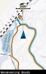
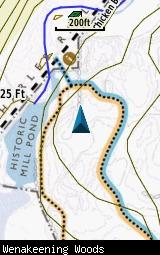
Screenshots
This KMZ map is set to Draw Order 32 so it will show 'beneath' your primary map on your Garmin KMZ-compatible GPS.
The images below are all from a Garmin GPSMAP 78sc. The image on the left is with no other maps displayed. The image on the right has the Garmin 24K NE series TOPO maps displayed.
Download
This KMZ is posted as freeware, so instead of paying for it, send me a note if you found this file helpful!
[email protected]

Once you have downloaded and unzipped the KMZ file, you can:
1) Display it on your Garmin GPS receiver by placing the file in the \Garmin\CustomMaps folder on your supported Garmin GPS receiver. For a list of supported devices, click here.
2) Display it in Google Earth by opening the file (FILE, OPEN).
Notification of Updates
If you would like to be notified when I update this or any of my KMZ maps, subscribe to my notification e-mail service by sending an e-mail to [email protected] with the subject line "subscribe gps_maps"
This is a notification list only, and the only posts you will receive are when my KMZ maps are updated. Your e-mail address will not be used for any other purpose (or provided to anyone else except me).
Version History
Version 1.00 (1/16/2016)
Initial release using undated Upper Charles Conservation Land Trust map.
Map Summary
Site details:
Name: Wenakeening Woods
Owner / Steward: Upper Charles Conservation Land Trust
State: Massachusetts
County: Middlesex
Primary city / town: Holliston
Primary city / town zip code: 01746
Other cities / towns in map area:
Area of conservation / recreation land: 101 acres or 0.16 square miles
NOTE: This is my calculation of the extents of the area(s) with publicly accessible trails on the KMZ map. This should be the area available for hiking or other recreation, but it will also include any portion of water bodies, marshes, swamps, etc. within the boundaries of the properties on the KMZ. It would also include inaccessible conservation land within the boundaries, such as a buffer zone of "Do not enter" land around a reservoir.
KMZ details:
File name: Wenakeening_Woods_ver_1.00.kmz
Current version: 1.00
Date published: 1/16/2016
Number of tiles: 1
KMZ file size: 299 KB
Draw order: 32
Does this KMZ overlap with any others? No
If so, which ones? N-A
Coverage of KMZ: 277 acres or 0.43 square miles
NOTE: this area includes the ENTIRE KMZ including white space / margins / legend, etc.
GPS coordinates of center of KMZ polygon (not necessarily the center of the map):
N 42°10.803
W 71°26.314
 Download Garmin Custom Map [296kB] (1470 Downloads)