Massachusetts: Upton: Stephans Farm Map
Created By: dbperry
Last Updated: April 12th, 2012 8:04pm
Map Coverage:
North: 42.1948°
West: -71.6394°
East: -71.6246°
South: 42.1864°
Country: United States
State: Massachusetts
Price: Free
![]()
![]()
![]()
![]()
![]()
![]()
![]()
Most Popular Maps
- My Trails-High Quality Trail and POI Maps
- Arizona Topo
- World Topo - Eastern
- WV-VA-KY Dec-29 2025 Public Map
- Florida Topo
Other Maps By dbperry (See All)
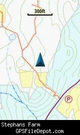
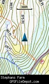
Stephans Farm, Upton MA 01568
A 116 acre parcel of conservation land purchased by the Town of Upton in 2003, Stephans Farm was a working farm for perhaps 150 years prior to becoming conservation land. In 1674, a 'praying village' on the land now occupied by Stephans Farm was the center of government for the Native American Nipmuc tribe.
More information about this property at:
http://www.upton.ma.us/pages/conservation-commission/town-conservation-land.php
and
http://www.upton.ma.us/media/Stefans%20Stewardship%20Plan%20SF%2012-07%202.pdf
Source Data
My KMZ map is created from the Upton Land Stewardship Committee map:
http://www.upton.ma.us/media/concom/townconservationland/Stephans%20Trail%20Map%20March%202012.jpg
See version history below for more info.
Screenshots
Download
I have posted this KMZ as freeware, so instead of paying me for it, send me a note if you found this file helpful!
[email protected]
 Download Garmin Custom Map [245kB] (1150 Downloads)
Once you have downloaded and unzipped the KMZ file, you can:
1) Display it on your Garmin GPS receiver by placing the file in the \Garmin\CustomMaps folder on your supported Garmin GPS receiver. For a list of supported devices, click here.
2) Display it in Google Earth by opening the file (FILE, OPEN).
Notification of Updates
If you would like to be notified when I update this or any of my KMZ maps, subscribe to my notification e-mail service by sending an e-mail to [email protected] with the subject line "subscribe gps_maps"
This is a notification list only, and the only posts you will receive are when my KMZ maps are updated. Your e-mail address will not be used for any other purpose (or provided to anyone else except me).
Support The Effort
If you find the map and this website useful please consider making a donation to offset hosting costs.
* You don't need paypal to donate but that is who will process the donation.
Version History
Version 1.00 (2012 Apr 13)
Initial release using Town of Upton map (see above) dated March 2012.