Massachusetts: Hopkinton: Waseeka Wildlife Sanctuary Map
Created By: dbperry
Last Updated: March 24th, 2012 7:03pm
Map Coverage:
North: 42.2316°
West: -71.4714°
East: -71.452°
South: 42.2109°
Country: United States
State: Massachusetts
Price: Free
![]()
![]()
![]()
![]()
![]()
![]()
Most Popular Maps
- My Trails-High Quality Trail and POI Maps
- Arizona Topo
- World Topo - Eastern
- Florida Topo
- WV-VA-KY Feb 3 2025 Public Map
Other Maps By dbperry (See All)
Waseeka Wildlife Sanctuary, Hopkinton, MA 01748
A small parcel of conservation land, owned and maintained by the Massachusetts Audubon Society. Although the entrance is in Hopkinton, about half of the property is in Holliston. The trails lead to a pond - created long ago when it was farmland - by the farmer who dammed the stream running through the property. The pond is now home to beavers, who can frequently be observed working on their lodges and swimming in the pond.
More information at:
http://www.massaudubon.org/Nature_Connection/Sanctuaries/Waseeka/index.php
If you enjoy using Mass Audubon properties, consider becoming a member:
http://www.massaudubon.org/support/support_join.php
Source Data
My KMZ map is from the Massachusetts Audubon Society map at
http://www.massaudubon.org/Nature_Connection/Sanctuaries/images/maps/waseeka_trails.pdf
See version history below for more info.
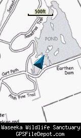
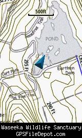
Screenshots
This KMZ map is set to Draw Order 25 so it will show 'beneath' your primary map (and also 'beneath' my 'Ashland State Park' KMZ <http://www.gpsfiledepot.com/maps/view/572/>) on your Garmin KMZ-compatible GPS. These two maps overlap, but by having Waseeka 'beneath' Ashland State Park, you can have both on your GPS at the same time and not have any important trail features obscured.
The image on the left is from a Garmin GPSMAP 78sc with no other maps displayed. The image on the right is from the same device with the Garmin 24K NE series TOPO maps displayed.
Download
I have posted this KMZ as freeware, so instead of paying me for it, send me a note if you found this file helpful!
[email protected]
 Download Garmin Custom Map [47kB] (1364 Downloads)
Once you have downloaded and unzipped the KMZ file, you can:
1) Display it on your Garmin GPS receiver by placing the file in the \Garmin\CustomMaps folder on your supported Garmin GPS receiver. For a list of supported devices, click here.
2) Display it in Google Earth by opening the file (FILE, OPEN).
Notification of Updates
If you would like to be notified when I update this or any of my KMZ maps, subscribe to my notification e-mail service by sending an e-mail to [email protected] with the subject line "subscribe gps_maps"
This is a notification list only, and the only posts you will receive are when my KMZ maps are updated. Your e-mail address will not be used for any other purpose (or provided to anyone else except me).
Support The Effort
If you find the map and this website useful please consider making a donation to offset hosting costs.
* You don't need paypal to donate but that is who will process the donation.
Version History
Version 1.00 (2012 Mar 24)
Initial release using undated Mass Audubon map downloaded on 2012 Feb 26.