Wilderness Trail OHV / ATV Park v3.0, KY Map
Created By: eaparks
Last Updated: May 29th, 2012 1:05pm
Map Coverage:
North: 36.7541°
West: 83.6653°
East: 83.5543°
South: 36.6556°
Country: United States
State: Kentucky
Price: Free
![]()
![]()
![]()
![]()
![]()
![]()
![]()
Most Popular Maps
- My Trails-High Quality Trail and POI Maps
- Arizona Topo
- World Topo - Eastern
- WV-VA-KY Dec-29 2025 Public Map
- Florida Topo
Other Maps By eaparks (See All)
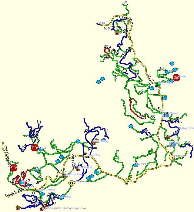
Wilderness Trail OHV / ATV Park GPS map, near Middlesboro, KY (60 miles N. of Knoxville, TN). ATV riding area encompasses 9,000 acres with 120 miles of trails. Map contains 65 POIs that include Parking/Staging Areas, Ponds, Old Home Sites, Lodging, Fuel, and other points of interest. Trails are located in the Colmar area and the Hances Ridge area.
10-21-11 - v1.0, original map
1-30-12 - v2.0; added 12 new trails and 13 more POIs, including lodging at Marty's ATV Oasis and a gas station... both ATV accesible. Improved accuracy of several exisiting trails.
5-29-12 - v3.0; added 5 new trails, improved the accuracy of 15 trails, added 10 more POIs.
8-21-13 - Added Map image.
Trails are color coded per trail difficulty as listed below. (see readme.txt file, also)
- Yellow line = the main Trail 66 & hard surfaced roads
- Green line = Easiest Trails (includes gravel roads)
- Blue line = Intermediate Trails
- Red line = Difficult Trails
- Red / Black dashed line = Extreme Trails
Before installing Wilderness Trail OHV Park, v3.0, manually uninstall my previous version if you had downloaded and installed it from GPSFileDepot.com.
 Download Windows Version [196kB] (2486 Downloads)