CityNav-Night Mode for Oregon 450 /Colorado/Dakota Map
Created By: yogazoo
Last Updated: February 1st, 2011 7:02pm
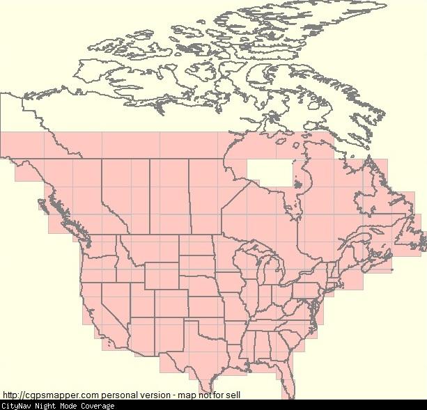
Map Coverage:
North: 63.8652°
West: -141.001°
East: -52.905°
South: 25°
Country: Canada, United States
Price: free
![]()
![]()
![]()
Most Popular Maps
- My Trails-High Quality Trail and POI Maps
- Arizona Topo
- World Topo - Eastern
- WV-VA-KY Dec-29 2025 Public Map
- Florida Topo
Other Maps By yogazoo (See All)
Are you the owner of a Garmin Oregon 450-550/Colorado/Dakota who uses City Navigator Maps and wonders why Garmin didn't see fit to provide us with a Night Mode? Every other Garmin GPS that is in production today includes this feature why not the Oregon/Colorado/Dakota?
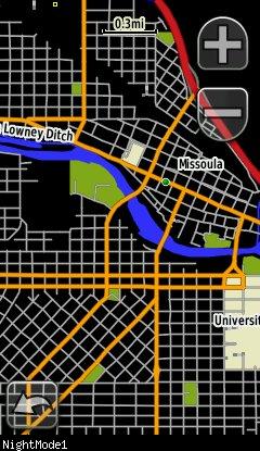
This map is a black background that will integrate seemlessly with City Navigator Maps to turn the white background black while still allowing you to see the City Navigator polygons, roads, lakes, rivers etc. When the sun goes down simply enable this map along with the City Navigator maps and you will be navigating glare-free! Map covers all of the continental US and the southern 2/3rds of Canada.
ONLY WORKS WITH GARMIN CITY NAVIGATOR MAPS!
Instructions: Unzip the folder and place the contents into the Garmin folder on your GPS or SD card. Enable the map along with City Navigator. Enjoy glare free navigation!
(a note for map developers: This map was generated with a draw priority of '30' and map detail levels that coincide with City Navigator maps. (detail levels are as follows 23-21-19-18)
 Download Windows Version [893kB] (4034 Downloads)
To report an error or if you have any questions regarding this mapset please contact me (yogazoo) at [email protected]. Thank You!
Example screen shot:
Map Showing Coverage Area:
Download Windows Version [893kB] (4034 Downloads)