Boyds Map of the Pines LE Map
Created By: Boyd
Page Last Updated: January 29th, 2012 5:01pm
Map Coverage:
North: 40.125°
West: 75.6235°
East: 73.9982°
South: 38.8745°
Country: United States
State: New Jersey
Price: Free
![]()
![]()
![]()
![]()
![]()
![]()
![]()
![]()
Most Popular Maps
- My Trails-High Quality Trail and POI Maps
- Arizona Topo
- World Topo - Eastern
- Florida Topo
- World shaded relief kmz
Other Maps By Boyd (See All)
Boyd’s Map of the Pines / LIDAR Edition
Version 1.0, January 29, 2012
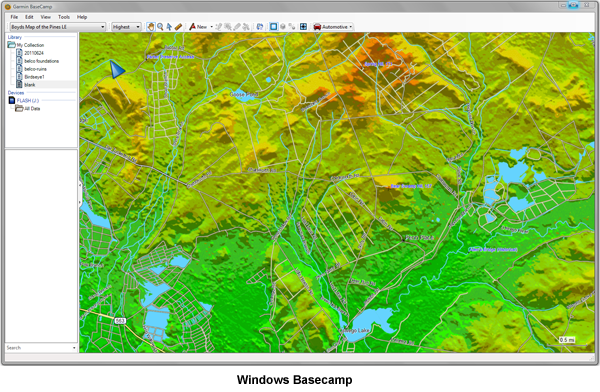
This map provides colorful and highly detailed shaded terrain for the southern half of New Jersey
(total of 87 USGS 24k quads) based on USGS National Elevation Dataset 1/9 arc second LIDAR
DEM. Full road, trail, water and placename data is also included. It is compatible with all Garmin mapping
GPS receivers as well as Garmin desktop software on both the Macintosh and Windows.
To make this map compatible with all Garmin devices and software, the original imagery was
converted to Garmin’s vector format at reduced resolution using special techniques and software
developed by the author. Although all of Southern New Jersey is covered, please note that LIDAR
data was only available for a portion of the area. You will notice a significant lack of detail outside the
LIDAR coverage.


Important Technical Note
Although this map has been tested on a variety of devices, the very high level of detail might cause
issues on some units. For this reason, please load this map on a memory card for testing if possible
instead of installing in internal memory. In the unlikely event that the map causes your GPS to
become unresponsive, you can simply remove the memory card to correct the problem. After
confirming that the map works properly on your device, it is suggested that it then be installed in
internal memory if available. You may notice a significant improvement in performance when the map
is installed in internal memory, due to the speed at which data can be accessed.
Compatibility
Windows XP, Windows Vista, Windows 7
• Garmin Basecamp 2.08 or newer
• Garmin Mapsource 6.14.1 or newer
MacOS X 10.4 or newer
Garmin Basecamp 2.1.2 or newer
Installation
Windows
First, install Garmin Basecamp unless Mapsource is already installed on your computer. Basecamp is
available at http://www8.garmin.com/support/download_details.jsp?id=4435
After downloading, right-click the PinesMap.zip file and choose "Extract All...". Open the PinesMap folder and double-click the file named Windows Installer.exe and follow the instructions. The maps will now be available for viewing in Basecamp or Mapsource, where they may also be sent to your GPS device.
To remove the map from your computer, use the Programs and Features control panel (Windows 7
and Vista) or Add/Remove Programs (Windows XP). Select Boyds Map of the Pines LE from the list
of programs and click the Uninstall button.
Macintosh
First, install Garmin Basecamp if it is not already on your computer. Basecamp is available here
(MacOSX 10.5.8 or newer req'd): http://www8.garmin.com/support/download_details.jsp?id=4449
For older versions of MacOSX, use this version of Basecamp:
http://www8.garmin.com/support/download_details.jsp?id=4939
It is important that you install Basecamp before attempting to install this map or the downloaded file
will not be correctly recognized.
After downloading, double-click the file named PinesMap.zip file to extract the compressed
files. Open the PinesMap folder and double-click the file named Boyds Map of the Pines LE.gmapi. Follow the prompts for Garmin
MapManager to install the map. After installation the map can be viewed with Basecamp and sent to
your GPS device with MapInstall.
To remove the map from your computer, run the Garmin MapManager program (found in your
Applications folder). Select Boyds Map of the Pines LE and choose File > Delete Map.
Data Sources
This map uses the same road, trail, hydrology and POI data as Boyd’s Map of New Jersey 2012. A
partial list of data sources follows:
Guy Thompson's Pine Barrens Points of Interest
NJDEP State Forest Trail Maps
NJDEP Placenames
NJDOT County Map Series
USGS National Elevation Dataset 1/3 arc-second DEM
USGS National Elevation Dataset 1/9 arc-second LIDAR DEM
USGS National Hydrology Database
US Census Bureau TIGER/Line® Shapefiles
US Census Bureau GNIS Place Names
Boyd's Map the Pines LE License Agreement
Please read this license carefully. By installing this map on your computer and/or GPS device, you
are agreeing to all of its terms. This map is copyright © Boyd Ostroff, 2012.
You are permitted to install this map on any computers or GPS devices that you own for personal,
non-commercial use. You may also redistribute this map for non-commercial purposes provided that
all files contained in the distribution folder, including this agreement, are included. You may not
include this map or any part of it as part of a commercial product for sale. You may not create
derivative works from the data in this map. Any use of this map for purposes other than those
described above requires the written consent of the author.
This software is provided 'as-is', without any express or implied warranty. In no event will the author
be held liable for any damages arising from the use of this software.
No claims are made as to the accuracy of the data contained in this map and the user assumes all
risks associated with its use. This map is intended for reference, educational and recreational
purposes only. The author will not be held responsible for any inaccuracies and no responsibility is
assumed for damages or other liabilities due to the accuracy, availability, use or misuse of the data
presented.
Boyd Ostroff
[email protected]
Garmin®, MapSource® , BaseCamp® and City Navigator® are registered trademarks of Garmin, Ltd. or its subsidiaries
 Download Universal (Mac & PC) Version [92MB] (2547 Downloads)