Massachusetts: Stow: Red Acre Map
Created By: dbperry
Last Updated: January 1st, 2013 4:01pm
Map Coverage:
North: 42.4477°
West: -71.4962°
East: -71.4787°
South: 42.4328°
Country: United States
State: Massachusetts
Price: Free
![]()
![]()
![]()
![]()
![]()
![]()
![]()
Most Popular Maps
- My Trails-High Quality Trail and POI Maps
- Arizona Topo
- World Topo - Eastern
- Florida Topo
- World shaded relief kmz
Other Maps By dbperry (See All)
Red Acre, Stow, MA 01775
CLICK HERE to preview the KMZ map in Google Maps
Red Acre is a parcel of conservation land in Stow MA that was purchased by the Stow Conservation Trust in 2002. Although some hiking across or along roads is required, a continuous hike can easily be made from the Gardner Hill conservation area, through Red Acre, into the Capt. Sargent Farm Conservation Area.
More information at:
http://www.stowconservationtrust.org/land.php
and
http://www.stow-ma.gov/pages/stowma_recreation/Walking%20and%20Hiking%20Trails/RedAcreWoodland.pdf
and
http://www.redacrefoundation.org/history.htm
Source Data
My KMZ map is from the Town of Stow Conservation Trust map:
http://www.stowconservationtrust.org/images/maps/RedAcre.jpg
See below for more information
If you enjoy using this property, consider becoming a member:
http://www.stowconservationtrust.org/donation.php
Screenshots
This KMZ map is set to Draw Order 45 so it will show 'beneath' the primary map on your Garmin KMZ-compatible GPS. It is also designed to show 'on top' of the following KMZ maps from my collection of local KMZ maps:
Captain Sargent Farm Conservation Area
Heath Hen - Flagg Hill
Gardner Hill
Assabet River National Wildlife Refuge
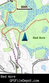
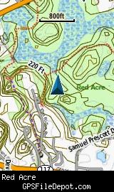
The image on the left is from a Garmin GPSMAP 78sc with no other maps displayed. The image on the right is from the same device with the Garmin 24K NE series TOPO maps displayed.
Download
I have posted this KMZ as freeware, so instead of paying me for it, send me a note if you found this file helpful!
[email protected]
 Download Garmin Custom Map [220kB] (929 Downloads)
Once you have downloaded and unzipped the KMZ file, you can:
1) Display it on your Garmin GPS receiver by placing the file in the \Garmin\CustomMaps folder on your supported Garmin GPS receiver. For a list of supported devices, click here.
2) Display it in Google Earth by opening the file (FILE, OPEN).
Notification of Updates
If you would like to be notified when I update this or any of my KMZ maps, subscribe to my notification e-mail service by sending an e-mail to [email protected] with the subject line "subscribe gps_maps"
This is a notification list only, and the only posts you will receive are when my KMZ maps are updated. Your e-mail address will not be used for any other purpose (or provided to anyone else except me).
Support The Effort
If you find the map and this website useful please consider making a donation to offset hosting costs.
* You don't need paypal to donate but that is who will process the donation.
Version History
Version 1.00 (2012 Dec 27)
Initial release using undated Stow Conservation Trust map (see above) downloaded on December 15, 2012.
Map Summary
Site details:
Name: Red Acre
Owner / Steward: Stow Conservation Trust
State: Massachusetts
County: Middlesex
Primary city / town: Stow
Primary city / town zip code: 01775
Other cities / towns in map area: <none>
Area of conservation / recreation land: 210 acres or 0.33 square miles
NOTE: This is my calculation of the extents of the area(s) with publicly accessible trails on the KMZ map. This should be the area available for hiking or other recreation, but it will also include any portion of water bodies, marshes, swamps, etc. within the boundaries of the properties on the KMZ. It would also include inaccessible conservation land within the boundaries, such as a buffer zone of "Do not enter" land around a reservoir.
KMZ details:
File name: Red_Acre_ver_1.00.kmz
Current version: 1.00
Date published: 12/27/2012
Number of tiles: 1
KMZ file size: 220 KB
Draw order: 45
Does this KMZ overlap with any others? Yes
If so, which ones?
Captain Sargent Farm Conservation Area
Heath Hen - Flagg Hill
Gardner Hill
Assabet River National Wildlife Refuge
Coverage of KMZ: 585 acres or 0.91 square miles
NOTE: this area includes the ENTIRE KMZ including white space / margins / legend, etc.
Lat / Long of center of KMZ polygon (not necessarily the center of the map):
N 42° 26.411'
W 71° 29.244'