Massachusetts: Windsor: Notchview Map
Created By: dbperry
Last Updated: July 7th, 2013 3:07pm
Map Coverage:
North: 42.5265°
West: -73.0485°
East: -72.9927°
South: 42.491°
Country: United States
State: Massachusetts
Price: Free
![]()
![]()
![]()
![]()
![]()
![]()
![]()
Most Popular Maps
- My Trails-High Quality Trail and POI Maps
- Arizona Topo
- World Topo - Eastern
- Florida Topo
- World shaded relief kmz
Other Maps By dbperry (See All)
Notchview, Windsor, MA 01270
Location Information
Notchview is the largest of the properties owned by the Trustees of Reservations, and is a popular place for cross country skiing in the winter. Trails at Notchview connect to the Windsor State Forest.
More information at:
http://www.thetrustees.org/places-to-visit/berkshires/notchview.html
and
http://www.xcskimass.com/ski-areas/about-notchview
and
http://www.xcskimass.com/index.php?option=com_content&view=category&layout=blog&id=7&Itemid=8
Source Data
My KMZ map is from the Trusteess of Reservations map (with permission):
http://www.thetrustees.org/assets/documents/places-to-visit/trailmaps/Notchview-Trail-Map.pdf
(See Version History below for more information)
If you enjoy the Trustees of Reservations properties, consider becoming a member:
http://www.thetrustees.org/membership/
iPhone / Android / Google Map Links
The links below will allow you to view an interactive version of the KMZ trail map on your computer or on your mobile device (iPhone / iPad / Android). By allowing the Google Maps website to 'use your location' on your device, you will be able to see your position displayed on the Google Map.
When opening the links on your iPhone, don't use the Google Maps app - allow the browser to open the link on the Google Maps website.
CLICK HERE to view the Notchview KMZ map in Google Maps
CLICK HERE to view the Notchview KMZ map in Gmap4 (terrain shaded map)
Screenshots
This KMZ map is set to Draw Order 32 so it will show 'beneath' the primary map on your Garmin KMZ-compatible GPS. It will also show beneath my KMZ map of Windsor State Forest if you have both of them loaded on your GPSr. Loading both KMZ maps will provide you with a seamless trail map of both properties on your GPSr.
Note that due to the wide coverage area of this map, it is actually 4 tiles. Keep that in mind when placing this on your Garmin GPSr - even though this is one KMZ, the number of tiles is limited to 100 across all the KMZ files loaded on most Garmin GPSr models (500 if you have a Garmin Montana or Oregon 600 series).
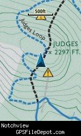
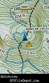
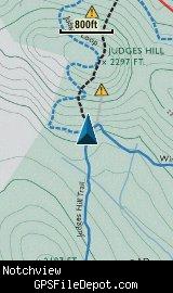
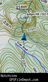
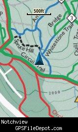
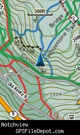
The image on the left in each row below is from a Garmin GPSMAP 78sc with no other maps displayed. The image on the right in each row below is from the same device with the Garmin 24K NE series TOPO maps displayed.
Download
I have posted this KMZ as freeware, so instead of paying me for it, send me a note if you found this file helpful!
[email protected]
 Download Garmin Custom Map [2MB] (1097 Downloads)
Once you have downloaded and unzipped the KMZ file, you can:
1) Display it on your Garmin GPS receiver by placing the file in the \Garmin\CustomMaps folder on your supported Garmin GPS receiver. For a list of supported devices, click here.
2) Display it in Google Earth by opening the file (FILE, OPEN).
Notification of Updates
If you would like to be notified when I update this or any of my KMZ maps, subscribe to my notification e-mail service by sending an e-mail to [email protected] with the subject line "subscribe gps_maps"
This is a notification list only, and the only posts you will receive are when my KMZ maps are updated. Your e-mail address will not be used for any other purpose (or provided to anyone else except me).
Support The Effort
If you find the map and this website useful please consider making a donation to offset hosting costs.
* You don't need paypal to donate but that is who will process the donation.
Version History
Version 1.01 (7/7/2013)
Version 7 of Google Earth introduced a new 'feature' - when opening KMZ files, the view automatically 'tilts' to an oblique angle. By specifying the tilt angle (zero) in the KML file, this version of the Notchview KMZ map (1.01) prevents Google Earth from tilting the view. There were no other changes to the map - so if you don't mind the tilt view in Google Earth, or if you are not using this KMZ file in Google Earth, there is no reason to download this update.
Version 1.00 (11/28/2012)
Initial release using Trustees of Reservations map dated December 2005.
Map Summary
Site details:
Name: Notchview
Owner / Steward: The Trustees of Reservations
State: Massachusetts
County: Berkshire
Primary city / town: Windsor
Primary city / town zip code: 01270
Other cities / towns in map area: <none>
Area of conservation / recreation land: 2,139 acres or 3.34 square miles
NOTE: This is my calculation of the extents of the area(s) with publicly accessible trails on the KMZ map. This should be the area available for hiking or other recreation, but it will also include any portion of water bodies, marshes, swamps, etc. within the boundaries of the properties on the KMZ. It would also include inaccessible conservation land within the boundaries, such as a buffer zone of "Do not enter" land around a reservoir.
KMZ details:
Current version: 1.01
Date published: 7/7/2013
Number of tiles: 4
KMZ file size: 2,082 KB
Draw order: 32
Does this KMZ overlap with any others? Yes
If so, which ones? Windsor State Forest
Coverage of KMZ: 4,469 acres or 6.99 square miles
NOTE: this area includes the ENTIRE KMZ including white space / margins / legend, etc.
GPS coordinates of center of KMZ polygon (not necessarily the center of the map):
N 42° 30.524'
W 73° 01.231'