Rhode Island: Tiverton: Weetamoo Woods Map
Created By: dbperry
Last Updated: January 8th, 2013 9:01pm
Map Coverage:
North: 41.6061°
West: -71.2071°
East: -71.1541°
South: 41.5552°
Country: United States
State: Rhode Island
Price: Free
![]()
![]()
![]()
![]()
![]()
![]()
Most Popular Maps
- My Trails-High Quality Trail and POI Maps
- Arizona Topo
- World Topo - Eastern
- Florida Topo
- World shaded relief kmz
Other Maps By dbperry (See All)
Weetamoo Woods & Pardon Gray Preserve, Tiverton, RI 02878
CLICK HERE to preview the KMZ map in Google Maps
These parcels of conservation land are rich in history and historical sites, including bridges, cellar holes, and stories of King Philip's War. Over five miles of trails - some on colonial era roads - provide ample opportunity for exploring. Weetamoo Woods is owned by the town of Tiverton and the Pardon Gray Preserve is owned by the Tiverton Land Trust.
More information at:
http://www.tiverton.ri.gov/recreation/recreation.html
and
http://tivertonlandtrust.org/properties.php
and
http://www.tiverton.ri.gov/recreation/WeetamooHabitat2.pdf
and
http://tivertonlandtrust.org/pdfs/weetamo-pardon-gray-2.pdf
Source Data
This KMZ map is from the Town of Tiverton map at:
http://www.tiverton.ri.gov/government/forms%20and%20notices/10_08_WWandPGmap.pdf
See version history below for more information.
If you enjoy using this property, consider becoming a member of the Tiverton Land Trust:
http://tivertonlandtrust.org/become_a_member.php
Screenshots
This KMZ map is set to Draw Order 32 so it will show 'beneath' your primary map on your Garmin KMZ-compatible GPS.
Note that due to the wide coverage area of this map, it is actually 4 tiles. Keep that in mind when placing this on your Garmin GPS - even though this is one KMZ, the number of tiles is limited to 100 across all the KMZ files loaded on most Garmin GPS receivers (500 if you have a Garmin Montana).
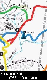
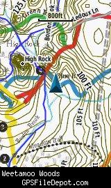
All of the images below are from a Garmin GPSMAP 78sc.
The image on the left is with no other maps displayed. The image on the right is with the Garmin 24K NE series TOPO map displayed.
Download
I have posted this KMZ as freeware, so instead of paying me for it, send me a note if you found this file helpful!
[email protected]
 Download Garmin Custom Map [870kB] (1457 Downloads)
Once you have downloaded and unzipped the KMZ file, you can:
1) Display it on your Garmin GPS receiver by placing the file in the \Garmin\CustomMaps folder on your supported Garmin GPS receiver. For a list of supported devices, click here.
2) Display it in Google Earth by opening the file (FILE, OPEN).
Notification of Updates
If you would like to be notified when I update this or any of my KMZ maps, subscribe to my notification e-mail service by sending an e-mail to [email protected] with the subject line "subscribe gps_maps"
This is a notification list only, and the only posts you will receive are when my KMZ maps are updated. Your e-mail address will not be used for any other purpose (or provided to anyone else except me).
Support The Effort
If you find the map and this website useful please consider making a donation to offset hosting costs.
* You don't need paypal to donate but that is who will process the donation.
Version History
Note: this page was updated on 1/9/2013 but the KMZ file was not modified
Version 1.00 (2012 Oct 03)
Initial release using Town of Tiverton map dated October 2008
Map Summary
Site details:
Name: Weetamoo Woods and Pardon Gray Preserve
Owner / Steward: Town of Tiverton and Tiverton Land Trust
State: Rhode Island
County: Newport
Primary city / town: Tiverton
Primary city / town zip code: 02878
Other cities / towns in map area: <none>
Area of conservation / recreation land: 1542 acres or 2.4 square miles
NOTE: This is my calculation of the extents of the area(s) with publicly accessible trails on the KMZ map. This should be the area available for hiking or other recreation, but it will also include any portion of water bodies, marshes, swamps, etc. within the boundaries of the properties on the KMZ. It would also include inaccessible conservation land within the boundaries, such as a buffer zone of "Do not enter" land around a reservoir.
KMZ details:
File name: Weetamoo_ver_1.00.kmz
Current version: 1.00
Date published: 10/03/2012
Number of tiles: 4
KMZ file size: 933 KB
Draw order: 32
Does this KMZ overlap with any others? No
If so, which ones? <none>
Coverage of KMZ: 6,251 acres or 9.8 square miles
NOTE: this area includes the ENTIRE KMZ including white space / margins / legend, etc.
Lat / Long of center of KMZ polygon (not necessarily the center of the map):
N 41° 34.851'
W 71° 10.829'