My Topos-High Quality Transparent Topo and Hydrology Maps Map
Created By: jbensman
Last Updated: January 28th, 2016 6:01pm
Map Coverage:
North: 41.7471°
West: -82.1562°
East: -92.4822°
South: 33.6715°
Country: United States
State: Alabama, Arkansas, Illinois, Indiana, Iowa, Kansas, Kentucky, Louisiana, Missouri, Ohio, Tennessee, Virginia, Wyoming
Price: Free
![]()
![]()
![]()
![]()
![]()
![]()
Most Popular Maps
- My Trails-High Quality Trail and POI Maps
- Arizona Topo
- World Topo - Eastern
- Florida Topo
- World shaded relief kmz
Other Maps By jbensman (See All)
These are transparent maps that show up on top of City Navigator which you still use for route calculation. They have topo lines and hydrology (streams, rivers, lakes, etc). The topo lines are from the USGS and they are more accurate than what is on the 24K USGS maps. I generally use a 10 foot contour interval (Some maps have 5 or 20 foot intervals). The hydrology is high resolution (equal to or better than the 24K USGS). I have also done lots of corrections to the hydrology by looking at ExpertGPS, Google Earth, and field checks. You will also notice intermentient streams show as a different shade of blue. What it looks like in the GPS is City Navigator with topolines and much better hydrology. See change log on how the maps are now changed and designed to work only with City Navigator.
This is the coverage of the maps as of Janurary 30, 2010:
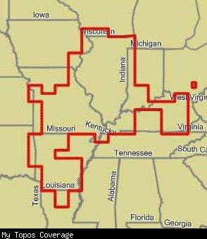
Keep checking back as I upload a new version every once in a while with more areas added.
To see what the maps look like on the GPS, see
http://www.gpsfiledepot.com/maps/view/53
Thanks to maps4gps for allowing me to use some of his great topos to add to my mapset. I used his maps to add GrandTeton and Yellowstone in WY (nothing else will be added in WY and will be using his maps to fill in some more states like MO, IN, KY, AR.
![]()
Donations appriciated -hundreds of hours have gone into these maps
 Download Windows Version [1GB] (9853 Downloads)
Download Mac Version [1GB] (2209 Downloads)
I have set up a listserve that I will send a message when I update one of my maps and a description of the changes. To subscribe [email protected] No one can post on it but me.
http://webpages.charter.net/jbensman/Maps.htm
Change log:
1-28-16: Lots of changes including lots of getting rivers water in the right place.
October 2, 2011: Numerous changes in the STL Area; Many changes in the Elgin Area, and a few Changes along the Ozark NSR. So far I have only been able to get the Windows version to upload. New Windows and Mac Installer
7-19-11: New Windows and MAC installers. Hundreds of corrections in the Saint Louis Area. Also a few in the Normal and Chicago vicinity.
3-7-11: Windows installer updated. Numerous edits mostly around STL.
1-26-11: Everything is now converted and seems to work great. The one exception is sometimes the lake name does not show up. While the hydrology layer shows, it will appear to not be there if you click on it and usually will not dispaly a name. This is not that big of a deal. Install My POIs to have lake names. Remember, the hydrology is designed to work with City Navigator. Using it with another street map could cause display problems.
1-9-11
BETA NOTE:
This is a beta for a beginning of a major change/improvement. One of the things that has bothered me with these maps from the start (and their one drawback) is the water polygons cover stuff up. For example, a major river that crosses a bridge covers it. A lake or river would also cover points or lines (such as a boat dock or boat ramp). I partially solved this by painstakingly editing polygons and also making some of them transparent. Transparency helps, but it also makes the river hard to see. After I tried Matt Bell’s CN Night mode map, it appeared he figured out how to get City Navigator’s lines (roads) and POIs to draw on top of a polygon-what I had never been able to figure out. He told me the secret. My first problem was while making these setting changes made it work, it messed up when the topos lines drew at different levels and caused major problems. This is because to make this work right, you have to match City Navigator’s draw levels. I ended up having to divide the maps into two parts. The hydro layer contains all the water polygons and are set with Matt’s discovery. The rest of the map (contour lines, stream lines, and island polygons) are in the other layer with their original settings. Both the hydro and other layer are still in the mapset.
For this beta, I have made the changes to 19 maps centered around the ST Louis Area. I will continue to change the other 100 plus maps (and then plan to change CO Transparent Topo). I am putting this out as a beta now in hopes people will try it and see if there are any problems. So far, I am more than pleased with the results! Please send me an email and let me know what you think. Remember, streams, contour lines, etc still draw on top of the roads.
When you select the map tiles to send to your GPS, you will notice some of the maps show a Hydro and Other after the map name. These are the maps that have been changed. The other maps still have the old problems.
This will now only work right with City Navigator.
Other changes:
Numerous minor edits to STL area (within 100 miles of STL)
Norfork and Bull Scholls Lakes in AR some edits
KY: Edited some maps along Green River to add ACOE construction data (dams etc).
December 4, 2010: Numerous minor edits to STL area (within 100 miles of STL) no areas added, MAC installer not updated