Florida Topo Map
Created By: -Oz-
Last Updated: October 23rd, 2011 8:10am
Map Coverage:
North: 31°
West: -88°
East: -79.2°
South: 24°
Country: United States
State: Florida
Price: Free
![]()
![]()
![]()
![]()
![]()
![]()
![]()
![]()
![]()
Most Popular Maps
- My Trails-High Quality Trail and POI Maps
- Arizona Topo
- World Topo - Eastern
- WV-VA-KY Dec-29 2025 Public Map
- Florida Topo
Other Maps By -Oz- (See All)
Introduction
The purpose of this venture is to create a detailed topographic map of the entire state of Florida at 24k detail. This map is created for Garmin GPS receivers and Mapsource.
Features
- Roads - Interstates, highways, arterial roads, residential roads, limited unpaved roads (2009 Tiger Data)
- Railroads
- High resolution water data - lakes, rivers, streams, and washes
- Federal Land Usage - Wilderness area, national parks, and military bases/ranges, native american reservations
- Borders - County and state boundary lines
- Elevation contours - 5ft intervals (equivalent to 24k)
- GNIS Points of Interest - summits, mines, falls, dams, cemeteries, towers, populated places, etc.
- Trails - trail coverage including all National Forests
- Bathymetric data to 300ft depth for the state
- Wetlands in Dry Tortugas National Park
- State Park Trails/campsites
- Florida National Trail and its accompanying trails; version July 2010
Coverage
This map covers the entire state of Florida.
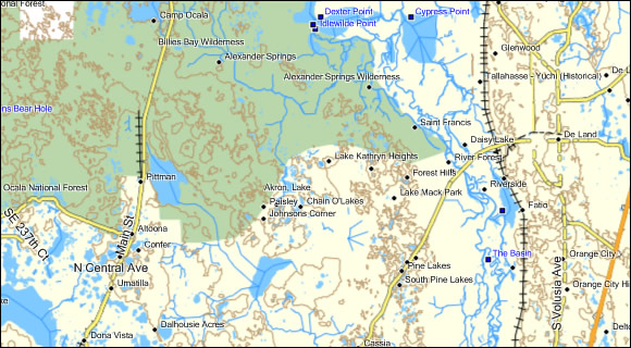
Screenshots
Below is a picture of the map inside of mapsource (6.14.X):
This screenshot compares the Florida Topo (left) to Garmin US Topo (middle) to Garmin Topo 2008 (rigth). With the exception of the DEM shading you can see that the Florida Topo is significantly more detailed.

The screenshot below shows some of the attributes this map has that the Garmin Topo's are lacking. In this case, its canoe waterways in the Everglades. Also, this map has bathymetric data.

Installation
Two options exist; for windows download and run setup. The map will then appear in Garmin MapSource and can be added to your GPS by selecting it in MapSource and sending it to the GPSr. For Mac download the mac version, extract it and double click the .gmapi file. Map Manager will then install the map for you.
Version 1.6 Released 31 Oct 10
Download Windows Version [137MB] (77027 Downloads)
Download Mac Version [146MB] (11730 Downloads)
GPS Usage
This map can be installed with any other Garmin Maps (How-To Tutorial). Then you simply hide and show other maps until you see the Florida Topo. For more detailed instructions check out this tutorial.
Support The Effort
Although this map is free, and always will be, if you find the map useful please consider making a donation to offset software, hardware, and hosting costs.
* You don't need paypal to donate but that is who will process the donation.
If you can't donate (or even if you can) another great way to help is by providing data for this map or other maps. If you have data please contact me.
Changelog
Version 1.60 (23 Oct 11)
- Created new Windows installer. This map now requires versions of MapSource GREATER than 6.13.X.
Version 1.60 (31 Oct 10)
- Reduced number of segments
- Fixed error where some names would be N.. O.....
Version 1.50 (16 Oct 10)
- Updated roads data to 2009
- Updated GNIS points; increased type of points shown
- Enabled POI seaching
- Increased segment size
- Included Florida Trails Database/Florida Trail Network
- Updated water data
- Improved installer/uninstaller information/Windows 7 compatibility
Version 1.00 (27 Feb 09)
- Initial release